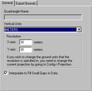
Elevation Export - General Options Panel
The General panel allows the user to specify the quadrangle name (DEMs only), vertical units, and grid spacing of an elevation grid being exported.
The Quadrangle Name field allows the user to enter the quad name to place in the header of a native format USGS DEM being exported.
The Vertical Units field allows the user to select the vertical units to use when exporting the data (i.e. meters or feet). Any input data not in the selected vertical units will be automatically converted on export.
The Resolution section allows the user to selected the grid spacing to use when generating the elevation data set. The default value is the average of the grid spacings of all the currently loaded elevation overlays.
When selected, the Interpolate to Fill Small Gaps option specifies that small gaps in between and within the data sets being exported will be filled in by interpolating the surrounding data to come up with an elevation for the point in question. This is useful when data sets do not line up exactly and so have small gaps in between them.